From Brazil: Doing Fieldwork by Satellite
September 2, 2010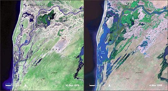

I’ll admit it, satellites boggle my mind. Even though I’m quite happy to listen to my phone tell me where to find the best Caribbean restaurant in Albany, I still can’t quite believe that our species has built machines that fly around our planet and tell us what they see. But the truth is that satellites are so last century—so much, in fact, that scientists have begun using them to document historical changes. The above picture, from NASA’s 38-year-old Landsat program, shows the Lake Djoudj region of Senegal during a drought in 1979 and during a flood 20 years later. Even at this small scale it’s clear how much information the pictures contain about how the land has changed.
At the International Ornithological Congress last week,Wesley Hochachka, assistant director of our Bird Population Studies program, heard about similar plans to use Landsat data to find out how Important Bird Areas in Africa are faring through the years—without researchers having to get on a plane and see for themselves. Here’s Wes:
Many field ornithologists take fieldwork for granted: they routinely assess habitat conditions by going into the field and taking direct measurements. However, in many areas of the world this isn’t feasible. Trained biologists are few, travel is difficult or costly, and at times their safety cannot be guaranteed. At this IOC meeting, Paul Donald from the UK’s Royal Society for the Protection of Birds described ways to get around these challenges using freely available data from satellites in order to monitor the status of areas at relatively low cost.
Donald and his colleagues began their work-in-progress with three observations
- Data from Landsat satellites can be accessed freely, and
- Human beings are still better at analyzing images than computers are, but
- Most people lack an easy means to work with satellite data.
To this end, Donald and his colleagues created a computer program that allows someone with relatively little training to select an area of conservation concern—they started with Important Bird Areas (IBAs) in Africa. The program displays 20 years worth of satellite images, with images at five-year intervals. A person can then fairly quickly measure the amount of land within the IBA and around it that was in the habitat type of interest, as well as other types of land cover—key information that is important to bird distributions. For example, someone could assess the forested parts of an IBA and as a result identify whether it or its vicinity were stable or were being degraded. (The authors published a paper on their work in 2009.)
In practice, the authors found their computer program was very effective. With only a few hours of training, someone could accurately measure forest (or grassland) cover of an area, and changes in status. As a result conservation organizations with few resources could do basic conservation assessments that would otherwise be impossible. Their next step is to conduct a general assessment of IBAs in Africa, and if this first test proves successful look for other areas in the world in which to make the computer program available.
The program will not provide all of the information ideally needed to assess conservation areas. Obviously, the presence of particular species of birds cannot be recorded from space, and partial degradation of forests may not be obvious from satellite images. However, in many cases the most critical information is whether or not areas of natural habitat are being encroached upon, or identifying which specific areas are facing the greatest immediate threats. With this information in hand, conservation organizations can devote their limited resources to address the most critical problems. As a result, I thought that the work described by Paul Donald was an important and creative use of satellite image data for direct conservation application.
More like this:
Martjan Lammertink’s news from the International Ornithological Congress, and Wes Hochachka’s report on European bird conservation from a meeting in Spain earlier this year.


All About Birds is a free resource
Available for everyone,
funded by donors like you


